The Wysis Way - Part 1 - Through the Cotswolds
You are here: Home > Cotswold Blog > The Wysis Way - Part 1 - Through the Cotswolds
Last year I decided to start walking between National Trails, as well as along them. I walked between the Cotswold Way at Ryeford near Stroud, and the Thames Path at Kemble near Cirencester. My route was the Thames & Severn Way which follows the line of the restored, and old Cotswold canals. Such were the sights, and history experienced, I had to write the blog I planned in 2 parts.
During my walks, and research for those blogs, I discovered William Morris. So, a new and enlightening experience began, and I visited places and wrote a blog about his legacy in the Cotswolds.
I plan a follow up blog about his life in London and his works.
The Wysis Way
While walking the Thames and Severn Way, signs also showed the Wysis Way. A google search revealed this is a 55-mile (88km) walkway between the National Trails the Thames Path, and Offa's Dyke Path in Wales. The walk crosses the Cotswolds, drops through the Severn Vale, and climbs into the Forest of Dean. It then joins the Offa's Dyke Path on its descent into the Wye Valley, ending in Monmouth, Wales. The Offa's Dyke Path then meanders through the Brecon National Park and Black Mountains, through which I commuted for two years when working in Wales. I had already scheduled an Offa's Dyke adventure for later this year, so this connecting walk is perfect.
I had read some negative reviews about the Wysis Way, saying there was nothing of any real note en-route, but I still decided to walk it. After all, there were possibilities:
1) To investigate links to my blogs, on Walking to the Thames Path and William Morris.
2) To see, and deep dive into the history of places, that may not be obvious tourist spots
So having walked part of it last November, I completed it with 8 more walks between late February and mid- April. My overwhelming personal conclusion is the negative reviews are not justified. In fact, I am again writing a two-part blog on my adventure such is the variety of history, sights, and scenery.
Therefore this first part covers the Wysis Way route in the Cotswolds, from Kemble to Painswick Beacon and the Cotswold escarpment at its Area of Natural Beauty (ANOB) boundary.
Wysis Way - Cotswolds overview
At Kemble the trail heads north sharing the Thames Path, and joining the Thames and Severn Way. After Sapperton it turns west along the Golden Valley at Daneway. It then separates and turns northwest through Oakridge Lynch, Bisley and Painswick, where it joins the Cotswold Way at Painswick Beacon. From the Beacon viewpoint, the onward route over Robinswood Hill, through Gloucester, and over May Hill is visible (pictured later).
Kemble

The Wysis Way starts at Kemble joining the Thames Path. At Thameshead a series of springs form the source of the River Thames, as described in Part 1 of my Walking to The Thames Path blog. It then heads towards Sapperton through Hailey's Wood. I did not walk around Kemble as the route starts before it, but its history, including links to photos, are included below.
The name Kemble appears to derive from the early Saxon word meaning 'boundary'. The first settlement on the site appears post Roman era (after 410AD), with the Saxons taking residence. Early artefacts include late Neolithic or early Bronze-Age flints from Clayfurlong Grove in 1989. Iron-Age and Angle-Saxon burials were discovered in West Hay field and West Lane, along with objects from those periods.
The village was mentioned in the Domesday Book (1086) as comprising thirty villagers and fifteen cottagers on land held by the Abbot of Malmesbury. Historically, in Wiltshire, Kemble was incorporated into Gloucestershire in 1897, and became a typical Cotswold village with a church, vicarage, school, smithy and a local quarry.
More about Kemble, with photos of key landmarks and buildings, can be found at https://www.cotswold.gov.uk/media/xsgcslbo/kemble-conservation-area-appraisal.pdf
Historical pictures, including those dating to 1900 can be found here
https://kembleandewen-pc.gov.uk/document-category/parish-history-archive/
Today, Kemble has two small airports. Cotswold Airport (previously known as Kemble Airport) was after 1983 used by the US Air Force as a maintenance facility. Previously, the RAF Red Arrows aerobatic display team was based there from 1966. Aston Down Airfield was formerly used by the RAF, and is now the home of Cotswold Gliding Club. More can be read about Kemble here https://en.wikipedia.org/wiki/Kemble,_Gloucestershire
Sapperton
The Wysis Way passes through Sapperton which has links to both my Walking to the Thames Path and William Morris blogs. First though some history, with précis and extracts from https://www.british-history.ac.uk/vch/glos/vol11/pp87-90#fnn5
A number of important ancient routes passed through the parish. Archaeological evidence suggests that a route through Sapperton and Daneway across the river Frome existed in the late Neolithic period. In 1086 the woodland in the parish measured 0.5 league by 0.25 league (fn. 6) and was presumably located at Hailey wood in the south-east part.
A church existed in the 11th Century, largely rebuilt in the 13/14th century, now named after St Kenelm. It, along with Sapperton Village, is on a hill looking down on the Golden Valley. The village mainly comprises 17/18th and early-19th-century Cotswold stone buildings. As described in my Walking to the Thames Blogs, the disused Thames and Severn Canal tunnel runs under the village.
So how is Sapperton linked to William Morris? The link is the Grade II listed Village Hall, which is associated with the Arts and Craft's movement that William Morris pioneered. The Village Hall website explains this further, extracts from https://www.oakridgevillage.org/history-group.html
The Gloucestershire village of Sapperton connected with three Arts and Crafts architects and designers: Ernest Gimson (1864-1919), Ernest Barnsley (1863-1926) and his younger brother Sidney Barnsley (1865-1926).They moved to the Cotswolds as young men in 1893 and lived and worked at Pinbury near Sapperton from 1894 until their deaths.
As explained in my William Morris blog, Ernest Gimson was mentored and influenced by William. Morris's daughter May commissioned Gimson to design 4 houses, and the Village Hall in Kelmscott, where the family had their Cotswolds home. May had clearly been impressed by his work, and Sir Nikolaus Pevsner described Gimson as, "the greatest of the English artist-craftsmen in his Pioneers of Modern Design" (1935).
The one public building in Sapperton connected with Gimson and the Barnsleys is the Village Hall. Ernest Barnsley was commissioned by Lilias, Countess Bathurst to design a building for use by the local community in 1912. The site chosen was the former village wheelwright's yard on which Gimson had set up a smithy in 1903.

After Sapperton the route turns west at Daneway, through the ancient Siccaridge Wood, along the Golden Valley, until it turns right toward as Oakridge Lynch, and then onto to Bisley Bisley (Seven Springs Well pictured below).
Bisley
Woodland is a dominant and ancient feature of the landscape around Bisley. Early records show an 896 charter for woodland belonging to an estate at Woodchester, and there was woodland worth 20shillings. on Bisley manor in 1086. The church was founded by the 11th century, and at Througham in the north-east part of the parish, a settlement existed by the 11th century
Bisley Village formed at the cross-roads of the Painswick to Cirencester and from Chalford to Birdlip roads. The Bear Inn on George Street was recorded from 1631. George Street was the site of the village pound and the village lock-up built in 1824 remains. The current village consists almost entirely of stone houses and cottages of the 17th and early 18th centuries. Exceptions are a jettied timber-framed building High Street, from a larger medieval house, and later houses such as Mount Pleasant, a row of 11 cottages stepped up the hill. Some historic pictures of Bisley can be found here https://bisleyhistory.co.uk/
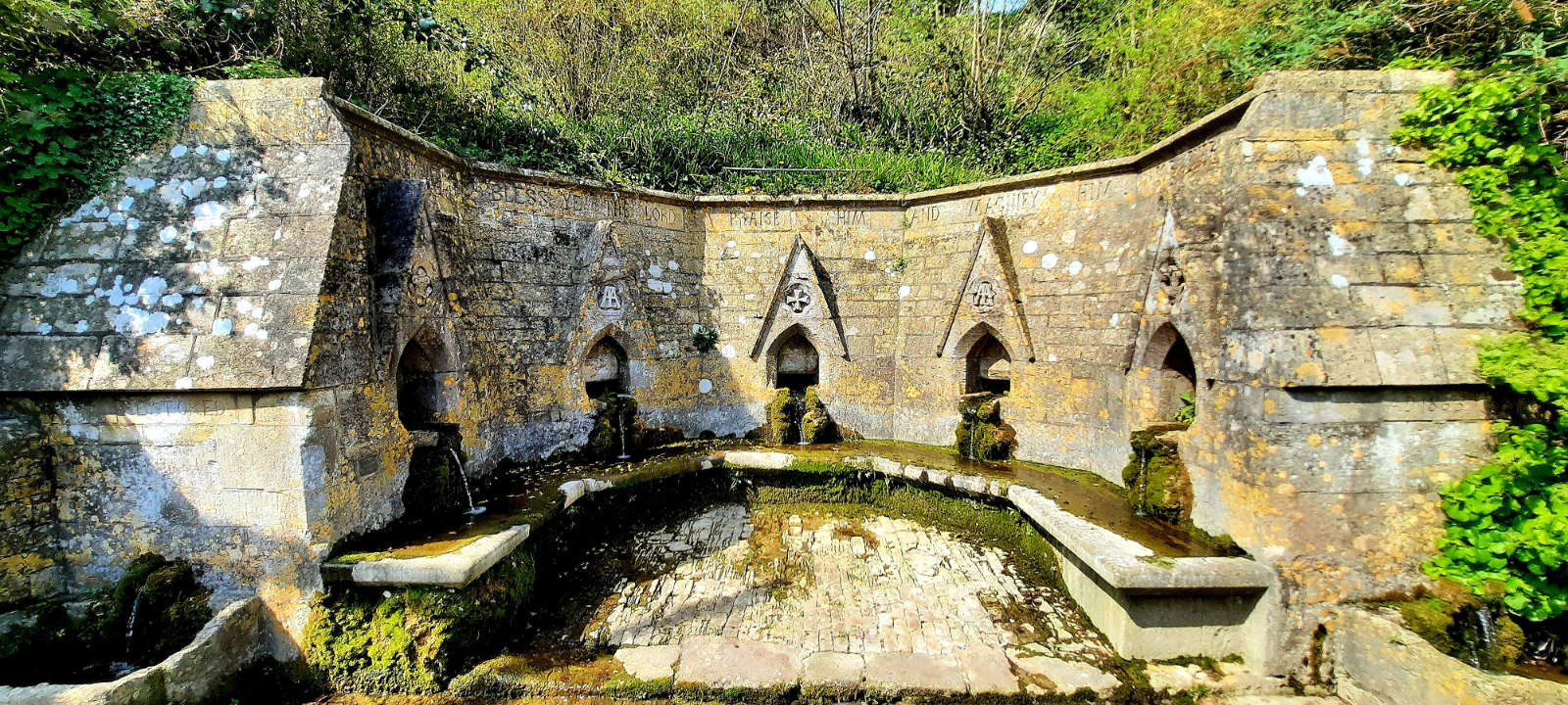
A prominent feature in Bisley is the Village Well, the extract below is taken from http://www.glosgen.co.uk/records/bisley.htm
Seven Springs Well
A public water supply is situated at Seven Springs in Well Road. The original five spouts are supplied from a spring under the churchyard; two additional spouts, fed from a spring in Inakers field, were installed in 1863 when the present well head was fitted. The well blessing ceremony, held annually on Ascension Day, dates from this time, and was started by the Rev. Thomas Keble. The wells are blessed by the Vicar of Bisley and children and parishioners decorate the well with flowers.
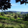
The Wysis Way then heads northwest with views down to Slad in Cider with Rosie country, named after the book by Laurie Lee. It skirts around Painswick giving stunning views of the town.
Painswick

A priest in Painswick is noted in the Domesday Book and evidence suggests a church was built between 1042 and 1066. Ernesi, a ricc Anglo-Saxon and Lord of the manor commissioned this. Painswick itself first appears in the Domesday Book of 1086, as Wiche, 'dairy-farm', when it is believed there was some nucleated settlement. The local monastery, Prinknash Abbey, was established in the 11th century.
The towns change of name is explained by this from Wikipedia.
The form Painswick first appears in 1237, but must originate in the name of an earlier lord of the manor, Pain Fitzjohn (d. 1137). Pain was a common Anglo-Norman name (itself originating in paiën, Latin paganus, 'heathen')
The church, now St Marys, was rebuilt from the 14th century, with its tall spire visible for miles around. The town grew from the wealth of the wool trade and is largely constructed from locally quarried Cotswold stone. It is best known for the parish church's 99 yew trees and the local Rococo Garden.
Painswick Beacon
Painswick Beacon as its commonly known, overlooks one of the five valleys between Stroud and Gloucester, the Painswick Valley. It is also known as Kimsbury Hill-fort, and Castle Godwyn. On a 7-acre spur of the Cotswold escarpment, the multivallate Iron Age hill fort has been dated to the first century BC. It is a scheduled monument, and a good account with historic maps can be found here https://www.british-history.ac.uk/rchme/ancient-glos/pp91-94

I have encountered many hill forts in the Cotswolds, this being the most well defined. Large multivallate hillforts are fortified enclosures of between 5ha and 85ha in area. They have two or more lines of concentric earthworks set at intervals of up to 15m. They date to the Iron Age period between 500 and 100 BC.
Records show that Kimsbury Hill Fort was in use from the first century BC. The defences on W., S.E. and N.E. are up to 55m wide, with three ramparts with two medial ditches. The inner rampart, of glacis construction, rises 1.5m. Pottery, coins and other archaeological finds have been found dating from the Iron Age through to the 3rd century AD in the Roman era. Sadly, the interior is almost entirely defaced by stone-quarrying and very surprisingly now contains part of a golf-course.
Summary and what's next
I am personally at a loss to see why anyone can say there is little of note. Except for Painswick and its Beacon, the route may not pass-through popular tourist spots, or have sign boards with hand fed information. But with the internet (beyond Wikipedia in some cases), its richness of history and importance can be found. The Iron Age features widely with some Bronze and Stone Age records too. Kemble also has the source of the River Thames and a military history. Sapperton is associated to the Arts and Crafts movement, and Cotswold Canals, and now I have read there were ancient walkways, I feel I may have walked along some. The Golden Valley is extraordinary, particularly in the golden hour at dawn and dusk. Finally, Bisley is a hidden gem, and Seven Springs Well is an architectural feature that deserves far more attention.

Part 2 of this blog covers the onward route through the Severn Vale, Gloucester, May Hill and the Forest of Dean, ending in the Wye Valley at Monmouth in Wales. It features the views from peak to peak of three hills, and explores the reason for the saying "blessed is the eye between Severn and Wye".
Last updated: 23 August 2023 - Please note: This blog was first written over a year old and things may have changed since the blog was written.